Map of US States: 50 States, Cities, Lists & PDFs
Whether you need a classroom reference, a trip-planning tool, or a quick way to settle the “50 vs. 52 states” debate, the United States offers 50 sovereign jurisdictions with clearly defined capitals, boundaries, and cities—from Juneau to Key West. This guide compiles maps, city markers, alphabetical lists, and verified resources so you can locate any state or capital in seconds.
Number of States: 50 · Largest State by Area: Alaska · Smallest State by Area: Rhode Island · Most Populous State: California · Capital City: Washington, D.C.
Quick snapshot
- The US has 50 states as sovereign jurisdictions (GIS Geography)
- The “52 states” confusion arises from counting Washington, D.C. or US territories like Puerto Rico alongside the 50 states (Wikipedia)
- Delaware became the First State in 1787; Alaska and Hawaii joined as the 49th and 50th states in 1959 (Wikipedia)
- Explore regional state groupings, alphabetical lists, and map resources for classroom or travel use (GIS Geography)
| Fact | Detail |
|---|---|
| Total States | 50 |
| First State to Join Union | Delaware (1787) |
| Last State to Join Union | Hawaii (1959) |
| Largest by Area | Alaska (665,384 sq mi) |
| Smallest by Area | Rhode Island |
| Capital City | Washington, D.C. |
| Major Territories (Not States) | 5 major territories (Puerto Rico, Guam, US Virgin Islands, Northern Mariana Islands, American Samoa) |
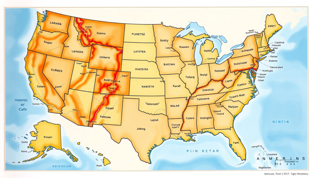
USA Map with States and Cities
Maps of the United States that show both states and cities typically colorize all 50 states and include a range of city markers—major metropolitan areas, regional hubs, and state capitals. The result is a reference tool that works for geography students, travelers, and anyone tracking news or events across specific locations.
“This USA map with states and cities colorizes all 50 states in the United States of America.”
Major Cities by Region
Regional groupings help you orient yourself quickly. The Northeast holds cities like New York City and Boston, while the South features Atlanta and Houston. The West Coast showcases Los Angeles, San Francisco, and Seattle. In the Midwest, Chicago and Detroit anchor the map.
Many maps distinguish between capital cities and largest cities—sometimes these are the same place, as with Phoenix, Arizona, where Phoenix AZ had a 2020 Census population of 1,608,139 according to Britannica. In other cases, they differ: California’s capital is Sacramento, but its largest city is Los Angeles.
State Borders and Capitals
State borders are drawn from federal surveys and treaty lines, making them precise boundaries on quality maps. Each state has an official capital city listed in federal records. For example, Alabama’s capital is Montgomery, and Alaska’s capital is Juneau, as documented by Britannica.
If your map shows capital cities alongside largest cities, you’re holding a reference-grade tool — one that distinguishes governance seats from population centers, which matters for government, logistics, and media research.
Large Map of USA with States and Cities
High-resolution or large-format maps give you more detail: zoomed state boundaries, expanded city labels, and sometimes road or terrain overlays. These formats suit classrooms, home offices, or anywhere you need to read small labels clearly.
High-Resolution Views
Websites like GIS Geography publish detailed maps that colorize all 50 states and label their major cities, from New York City down to smaller regional centers. These are often available as interactive web maps or downloadable images optimized for large screens.
Satellite and Road Overlays
Some mapping tools layer satellite imagery over state boundaries, letting you see terrain alongside political borders. Road overlays add highways and interstates, making these maps practical for trip planning or logistics analysis.
“The biggest state in the USA is Alaska, while the smallest is Rhode Island, in terms of area.”
A large, clearly labeled state map isn’t just decorative — it’s a working reference for route planning, demographic research, or classroom instruction that demands legibility from across the room.
US States List
A straightforward list of all 50 states provides a clean reference for anyone who needs the complete roster without searching through longer articles. These lists typically include state names, sometimes with abbreviations, entry order, or capital cities alongside each name.
Full List of 50 States
The 50 states, listed in the order they joined the Union, start with Delaware (December 7, 1787) and end with Hawaii (August 21, 1959). This chronological ordering reflects the constitutional process through which each territory applied for and received statehood.
State Abbreviations
Standard two-letter abbreviations are used in postal addresses, GPS systems, and shorthand references. These include AL for Alabama, AK for Alaska, AZ for Arizona, and so on through WY for Wyoming. The list is standardized by the United States Postal Service.
Alphabetical order is easier to search by name; chronological order tells you the historical story of westward expansion. Choose the list format that matches your actual use case.
How Many States in USA: 50 or 52?
This question comes up regularly, and the answer is straightforward: the United States has 50 states. The confusion around “52 states” stems from different ways people count geographic entities connected to the US.
Official Count
Under the US Constitution, there are exactly 50 states. This is confirmed by Wikipedia and corroborated by sources like GIS Geography. Each state is a sovereign jurisdiction with its own constitution, elected government, and representation in Congress (except for the two senators each state receives).
Common Misconceptions
The “52 states” count sometimes includes Washington, D.C., which is not a state and has no voting representation in Congress. US territories—Puerto Rico, Guam, the US Virgin Islands, the Northern Mariana Islands, and American Samoa—also sometimes appear in informal counts. None of these entities hold statehood status under the Constitution.
If you encounter a “52 states” reference in a news article or textbook, it’s likely an error. The authoritative source is the Constitution and the official statehood record maintained by the National Archives.
50 States List Alphabetical Order
The alphabetical list is the most commonly used format for quick reference, from Alabama to Wyoming. This ordering is what you’ll find in most phonebooks, government databases, and classroom materials.
A–Z Listing
Alabama, Alaska, Arizona, Arkansas, California, Colorado, Connecticut, Delaware, Florida, Georgia, Hawaii, Idaho, Illinois, Indiana, Iowa, Kansas, Kentucky, Louisiana, Maine, Maryland, Massachusetts, Michigan, Minnesota, Mississippi, Missouri, Montana, Nebraska, Nevada, New Hampshire, New Jersey, New Mexico, New York, North Carolina, North Dakota, Ohio, Oklahoma, Oregon, Pennsylvania, Rhode Island, South Carolina, South Dakota, Tennessee, Texas, Utah, Vermont, Virginia, Washington, West Virginia, Wisconsin, Wyoming.
With Flags and Nicknames
Many alphabetical lists also include state nicknames for richer reference. Delaware, for instance, is known as “The First State” per Study.com. Alabama carries the nickname “The Heart of Dixie.” State flags add visual anchors for classroom use or educational quizzes.
“Delaware: The ‘First State’ has the lowest average elevation.”
Alphabetical order is easy to scan, but it obscures regional patterns. If you’re planning travel or analyzing demographics, a regional grouping—Northeast, Midwest, South, West—will serve you better than alphabetical search.
Related reading: Texas Flooding Flash Flood Camp Mystic · Philadelphia Eagles vs Dallas Cowboys Match Player Stats
lovetoknow.com, studentandwriter.com, youtube.com, factmonster.com, state.1keydata.com, expertrating.com, en.wikipedia.org
Whether plotting a cross-country road trip or studying geography, this labeled USA states map with cities and free PDFs adds valuable detail to any exploration.
Frequently asked questions
What is the capital of each US state?
Each state has an official capital city. For example, California’s capital is Sacramento, Texas’s capital is Austin, and New York’s capital is Albany. Capital cities are listed in federal records and confirmed by authoritative sources like Britannica and Fact Monster.
Are there maps showing US states only?
Yes. State-only maps omit city markers and focus on boundaries. These work well for classroom activities where students label state borders or for quick geographic reference without visual clutter.
How do US states differ from territories?
US states are sovereign jurisdictions with constitutional representation in Congress. Territories like Puerto Rico and Guam have their own governments but no voting congressional representation and are not states under the Constitution.
What is the area of the largest US state?
Alaska is the largest state by area, covering 665,384 square miles. Texas is second at 268,596 square miles. Rhode Island is the smallest state by area, as confirmed by Maps of World.
Which US state has the most cities?
California has the largest urban population centers, with Los Angeles and San Diego among its major cities. Texas and Florida also have extensive city networks. State capitals often overlap with largest cities in nine states, including Phoenix, Atlanta, and Honolulu.
Can I print a US states map?
Yes. Many mapping websites offer printable PDFs or high-resolution images. Look for formats labeled “printable” or “PDF” on sites like GIS Geography or Maps of World. Ensure the resolution is at least 300 DPI for clean printing.
What are the regions of US states?
The standard regional grouping is four parts: the Northeast (Maine to Pennsylvania), Midwest (Ohio to North Dakota), South (Texas to Florida), and West (California to Alaska). Regional maps help with demographic, cultural, and political analysis.
Geography students and researchers who master the 50-state framework gain a foundational tool for understanding regional patterns, demographic analysis, and cross-state comparisons.
More related posts
 How Did Heath Ledger Die – Cause, Age and Key Facts
 Gabriel Nadeau-Dubois: From Student Activist to Québec Deputy
 Dek Hockey de la Capitale – Leagues Schedules Registration Guide
 Grocery Stores Closed Easter Sunday: Tesco Lidl Aldi Dunnes Hours
 Texas Flooding Flash Flood Camp Mystic – Timeline Causes Casualties
 How to Relieve Constipation on the Toilet Immediately
 2024 Ford Bronco Sport: Price, Specs, Reliability & RAV4
 Milky Way Cocktail Bar – Montréal Location and Facts